Shipping and chokepoints
Strait of Hormuz map: what each location means for shipping
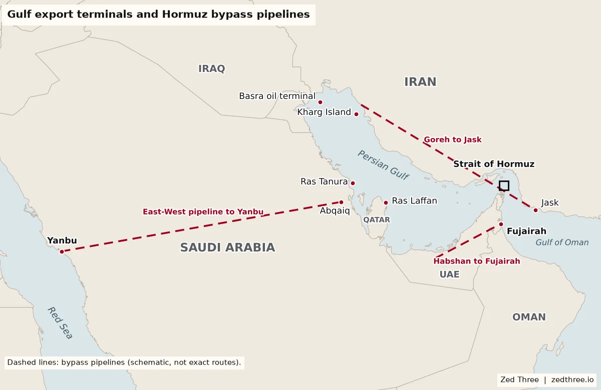
Annotated Strait of Hormuz maps showing Iran, Oman's Musandam peninsula, the islands, the main ports and the pipelines that bypass the strait, and what each means in 2026.
Guide
Shipping and chokepointsLast updated
5 minute read
By Zed Three analysts
Short answer
The Strait of Hormuz links the Persian Gulf to the Gulf of Oman, with Iran to the north and Oman's Musandam peninsula to the south. It is about 21 miles wide at its narrowest. The shipping lanes lie in Omani waters, while Iran holds the islands and the port of Bandar Abbas on the northern shore.
Last updated
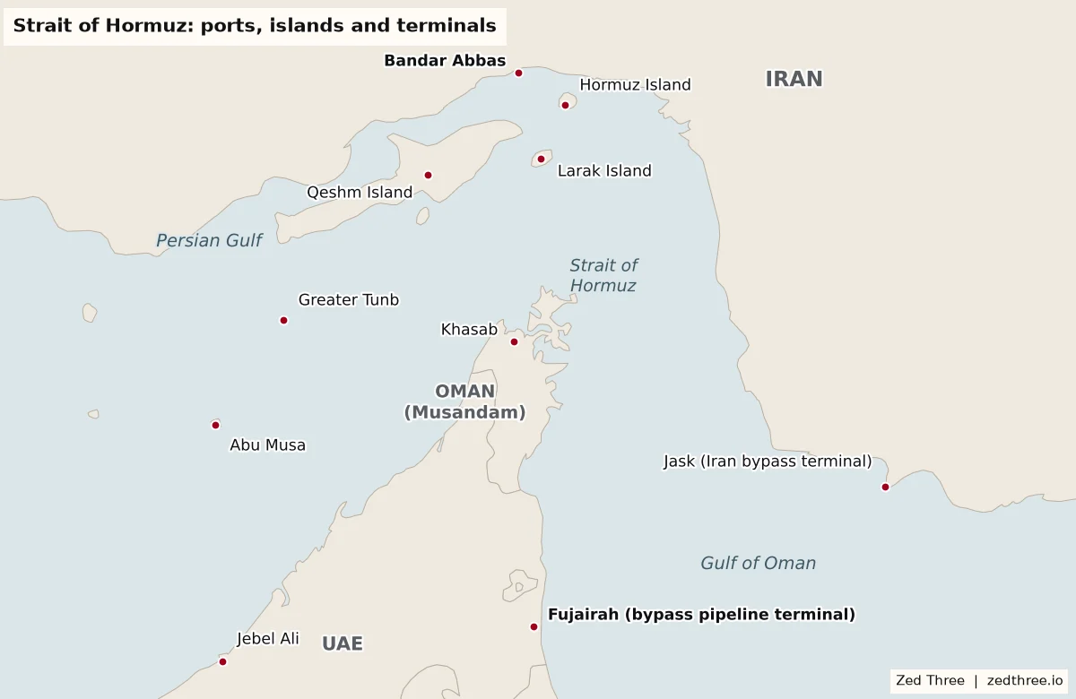
| Location | What it is | Why it matters in 2026 |
|---|---|---|
| Bandar Abbas | Iran's main port on the strait and a naval base | The center of Iranian naval activity overlooking the inbound and outbound lanes |
| Qeshm Island | Iran's largest island, west of Bandar Abbas | US forces struck an air defense site on the island on Nov 3 |
| Hormuz and Larak islands | Small Iranian islands at the bend of the strait | They sit closest to the main shipping channel |
| Musandam and Khasab | Oman's exclave on the southern shore and its main town | The traffic separation scheme lies in Omani territorial waters off this coast |
| Abu Musa and the Tunbs | Islands held by Iran since 1971 and claimed by the UAE | They lie on the western approach used by ships heading to and from Gulf ports |
| Fujairah | UAE port on the Gulf of Oman, outside the strait | End point of the UAE bypass pipeline, rated at about 1.8 million barrels a day |
| Jask | Iranian terminal on the Gulf of Oman | Iran's own bypass outlet, with limited effective capacity |
| Yanbu | Saudi port on the Red Sea | End point of the East West pipeline, Saudi Arabia's main route around the strait |
Free weekday briefing
Get Chokepoint in your inbox
The five stories that move markets, supply chains and deals, each with the so what worked out. Five minutes, every weekday morning.
Who holds which shore
The northern shore is Iranian along its whole length. Bandar Abbas is Iran's main port on the strait and a base for its navy. Just to the west lies Qeshm, Iran's largest island, and at the bend of the strait sit the smaller islands of Hormuz and Larak, which are the closest land to the main shipping channel.
The southern shore at the narrowest point belongs to Oman. Musandam is an Omani exclave, separated from the rest of the country by UAE territory, and its main town is Khasab. Further west, Abu Musa and the Greater and Lesser Tunb islands have been held by Iran since 1971 and remain claimed by the UAE. Ships bound for Dubai, Abu Dhabi, Qatar, Saudi Arabia, Kuwait and Iraq all pass this cluster of islands.
Where the shipping lanes run
Shipping normally follows a traffic separation scheme adopted by the IMO in 1968 at the proposal of Iran and Oman. It has one inbound and one outbound lane, each two nautical miles wide, divided by a two mile separation zone. The entire scheme lies inside Omani territorial waters, because the deepest water runs along the Musandam side.
That pattern has broken down in 2026. Ships are now advised not to use the scheme because of reported mines. Oman has published a waiting area and a temporary eastbound corridor in its waters, while Iran treats a northern route as its own responsibility. Mariners are therefore working with two competing sets of instructions in a strait where Iran's and Oman's territorial seas overlap.
The terminals inside the Gulf
Almost every major Gulf energy terminal sits behind the strait. Saudi Arabia loads crude at Ras Tanura, Iraq at its Basra terminals, Kuwait at Mina al Ahmadi and Iran at Kharg Island. Qatar ships its LNG from Ras Laffan, and several of its LNG production units were damaged at the start of the war. Jebel Ali in Dubai, the region's largest container port, is also inside the strait.
Before the war, about 20 million barrels a day of oil passed through Hormuz, roughly a fifth of world consumption, along with about a fifth of global LNG trade. Saudi Arabia supplied about 38% of the crude flow. About 84% of the crude and 83% of the LNG went to Asia, and China, India, Japan and South Korea together took 69%.
The bypass routes on the second map
Three pipelines can move oil around the strait. Saudi Arabia's East West pipeline runs from Abqaiq to Yanbu on the Red Sea and is rated at 5 million barrels a day, after a temporary conversion lifted it to 7 million in 2019. The UAE pipeline from Habshan to Fujairah on the Gulf of Oman is rated at about 1.8 million barrels a day. Iran's line from Goreh to Jask has an effective capacity of about 300,000 barrels a day and stopped loading after September 2024.
Before the war, only about 2.6 million barrels a day of Saudi and UAE bypass capacity was unused. That is the core of the map's message: the pipelines help, but they cannot replace a flow of about 20 million barrels a day. Fujairah and Yanbu also sit near their own risks, with Fujairah just outside the strait and Yanbu on the Red Sea, which has its own shipping crisis.
What the map shows about risk right now
Distance is the problem. Ships in the strait pass within a few miles of Iranian islands and coastline, so mines, drones, missiles and boarding teams can reach them quickly. On Nov 3 a tanker was hit by two projectiles about 14 nautical miles northeast of Limah on the Musandam coast, and US forces struck an air defense site on Qeshm. The Revolutionary Guard also claimed that four tankers hit mines in a prohibited lane south of the strait, a claim that has not been independently verified. Iranian officials have suggested that undersea cables in the Gulf could become targets.
Traffic reflects that. Before the war, more than 80 ships crossed the strait each day. In the first half of Nov 4, only a handful of crossings showed on ship tracking data. October totals were higher, at roughly 750 transits once ships sailing without tracking are counted, but that is still a fraction of normal. On Nov 3 Iran called the US reply to its conditions for reopening not convincing, while Qatar continues to mediate.
How to use this map in planning
Start by placing your own exposure on it. List suppliers, refiners and LNG sellers that load inside the Gulf, and mark which could switch to Yanbu or Fujairah. Note which of your cargoes are bound for Asia, since that is where most Gulf energy goes, and which inputs such as fertilizer, plastics and aluminum are made in Gulf industrial zones.
Then set triggers. A formal reopening deal, a change in IMO routing advice, a strike on a bypass terminal or a mine incident in the Omani corridor should each prompt a review of inventory, freight and insurance. The strait reopening would not end the risk overnight, because mines and insurance conditions would take time to clear.
What happens next?
We assess it is likely that Hormuz shipping remains disrupted through the end of December.
We assess it is unlikely that a deal to reopen the strait is agreed by Nov 30.
We assess it is unlikely that ships return to normal use of the traffic separation scheme before the end of December, even if a deal is reached.
Likelihood ranges are Zed Three editorial judgments as of Nov 4, 2026, not advice.
Free industry newsletter
Get Chokepoint free
The free weekday briefing read by risk and operations leaders. The five stories that move markets, supply chains and deals, each with the so what worked out, every weekday morning.
Related chokepoints
Related country risk assessments
Frequently asked questions
Where is the Strait of Hormuz?
Between Iran and Oman's Musandam peninsula, linking the Persian Gulf to the Gulf of Oman and the Arabian Sea.
Which countries border the Strait of Hormuz?
Iran to the north and Oman to the south. The UAE borders the approaches on both sides of Musandam.
How wide is the Strait of Hormuz?
About 21 miles at its narrowest point. The traffic lanes inside it are only two nautical miles wide each.
Who controls the islands in the Strait of Hormuz?
Iran holds Qeshm, Hormuz, Larak, Abu Musa and the Greater and Lesser Tunb islands. The UAE claims Abu Musa and the Tunbs.
Can ships or oil avoid the Strait of Hormuz?
Ships cannot reach Gulf ports any other way. Some oil can bypass the strait through Saudi and UAE pipelines to Yanbu and Fujairah, but far less than normally passes through it.
Is the Strait of Hormuz open right now?
As of Nov 4, 2026, it is not open to normal commercial traffic. Only a handful of crossings showed on tracking data in the first half of the day, against more than 80 a day before the war.
Related guides
Free custom sample
Get a free sample threat report on shipping and chokepoints
Tell us your routes, suppliers or sites and Zed Three will build a custom sample threat report around them.